As telecom companies work to keep systems and infrastructure operating, while innovating and adding new capabilities, they must find ways to be more efficient and cut costs. In this post, we talk with Nearmap’s Tim Frank, Senior Director of Marketing, to find out how telecom companies are using the latest aerial imagery technology to improve operations.
What challenges do telecom companies face today and how can they better apply aerial imagery to help solve them?
With the increasing demand for expanded network coverage and newer mobile technologies, telecom companies are constantly faced with installing new infrastructure while maintaining existing systems. This includes fiber networking, transmission towers, cellular antennas, buried infrastructure and other critical parts of the telecom infrastructure.
In this line of work, field specialists who visit sites, collect data, plan, analyze and inspect ground conditions are critical to operations. Because on-site work is time intensive, telecom companies are continually looking for ways to be more efficient. In other words, they’re trying to reduce the time, costs and complexity of working in the field. That’s where mapping, imagery and geographic information system (GIS) technologies come into play.
If field specialists can access and view accurate data about locations without traveling to the sites, they can do their jobs faster. They don’t have to walk across large areas of land to try to identify something that could otherwise be found more quickly using a broader perspective. This trend of working remotely is sweeping the industry, meaning companies with the most advanced technology will have an advantage over the competition and make decisions more efficiently.
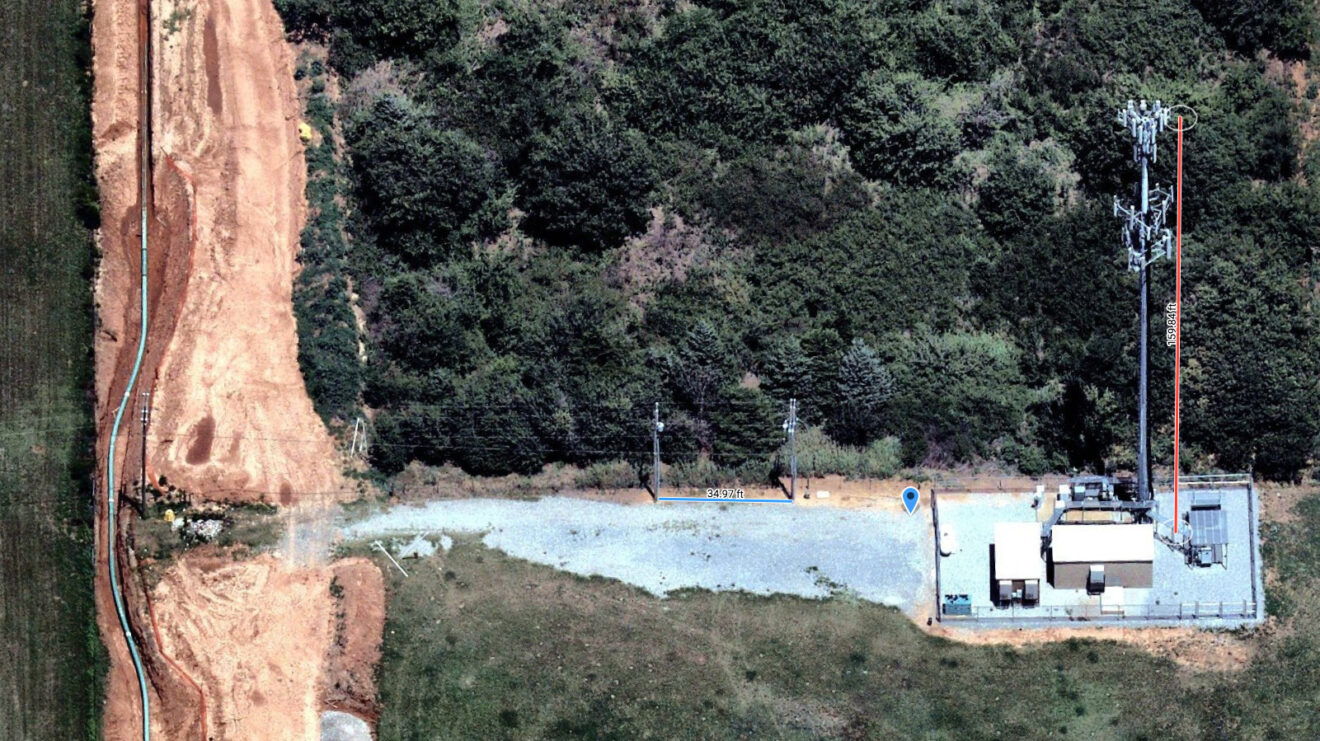
What approaches are companies currently using to deploy assets? How could they be more efficient or improve their operations?
As mentioned, telecom companies rely heavily on field operations teams for deploying and managing assets. They’re looking for details such as terrain, accessibility and routes. They also want to understand surroundings.
For example, they’d want to know if an area has land that’s protected in any way (historical districts, wetlands, national parks, etc.) They also want to understand potential risks of a given location – anything from vegetation, water tables, surrounding buildings or structures.
Leading telecom companies are leveraging mapping, GIS and aerial imagery technologies to improve the speed and accuracy of collecting and verifying data. For example, telecom companies might use Esri’s ArcGIS platform to overlay telecom assets on a map. It’s important for them to be able to see where the assets are or where they’re planned. But the map by itself doesn’t provide context. That’s where aerial imagery plays a critical role. High-definition aerial photos provide that visual context of what’s actually on the ground and how it has changed over time.
What types of solutions are available?
Instead of relying on satellite imagery, which is typically outdated and low resolution, businesses are turning to more current and accurate sources. Nearmap captures high-resolution aerial imagery of 70% of the US (focused around populated urban areas), and updates its photomaps multiple times per year.
One of the key differentiators in this system is the speed with which images are processed and published via a cloud-based delivery system. Nearmap uses pre-built services that leverage massive data pipes, allowing for any volume. Because the entire process – capture, manage and delivery – is streamlined, the aerial imagery is online within days of the flights.
More importantly, customers have instant access, which eliminates the need for ongoing maintenance. In contrast, imagery from other sources such as custom flights or drones may be able to capture small areas of land, but they don’t scale easily. These also introduce complexity and added cost because they require resources to store, operate, manage and maintain equipment as well as large amounts of data.
What should companies look for in a provider and what are some best practices for making a selection?
Telecom businesses should be looking for imagery that is current, high resolution, easy to access and easy to integrate with complementary technologies such as GIS and CAD systems. They should evaluate whether or not the imagery is of a consistently high resolution for all areas. They should also look at whether or not the imagery can be accessed in an easy to use browser interface, allowing anyone to get up and running immediately. Companies should also consider the value of being able to compare and analyze changes over time with historical imagery and multi-perspective views.
Being able to access this type of visual data not only streamlines fieldwork but also validates and corroborates other data sources, aids communications and reports, and saves time and money. Companies that use this type of aerial imagery are able to focus on operational efficiency without added strain on company resources.
Tim Frank is senior director of marketing at Nearmap. Before joining the company in 2015, he managed global demand marketing for Symantec and several other high-tech startups for more than 15 years. He earned a bachelor’s degree in marketing communications from Brigham Young University.
For more information click here.